Public Transit in Butler Tarkington
- May 11, 2020
- 6 min read
Updated: Apr 14, 2025
A version of this post originally appeared as an article in the Butler Tarkington Neighborhood Association March 2020 newsletter in advance of widespread system changes being planned by IndyGo in June of 2020. These changes have since been postponed due to the COVID-19 pandemic.
Mass transit in the Butler Tarkington neighborhood has almost always centered two dominating institutions within the boundaries of the present day neighborhood. First, was Fairview Park and the second is the successor to the park, Butler University.
Near the end of the 19th century, the first mass transit system serving the area which would become Butler-Tarkington was the trolley line for Fairview Park, operated by the Citizen Street Railway Company (later known as the Indianapolis Street Railway Company). The railway company also happened to own Fairview Park, and the trolley line was a business move to ensure customers could reach the park that was well outside the city limits at the time. The route commenced in 1890 and had regular service to the park while it was open.

The streetcar line serving Fairview came up Boulevard Place (then called Senate), took a left on 38th Street, went westbound before taking a right on Rookwood, then a left (westbound) on 42nd before finally taking a right on Haughy Avenue adjacent to present day CTS. At this point the line entered the park, and navigated a large loop for the return trip downtown. Aside from this, the nearest transit line at the time was the Broad Ripple/downtown streetcar line which then ran along Pennsylvania, before cutting over to College. Later, the Fairview line was moved from Rookwood and continued north on Boulevard, although it still turned on 42nd street to head west before taking the loop inside the park.
The Fairview line remained in place when the park was obtained by Butler University in 1922, with the large loop turnaround still being used. A mock up of a streetcar (visible to the left in the photo below) provided a waiting area for students, staff, and residents of the neighborhood catching the next car to downtown.

With the expansion of development inside the neighborhood in the 1920's and 1930's, other transit lines were added. In 1932, Indianapolis Railways, Inc. bought the transit lines around Indianapolis, and introduced the use of trackless trolleys (basically a bus which ran on an overhead electric line, but needed no track) in other parts of the city. The image below is an excerpt from a larger aerial photo shows the Butler campus in 1938 (view is looking south over Jordan Hall). Of note, on the right side of the image is the streetcar loop, with the mock up street car waiting area visible at the peak of the loop.

The Butler Line, or Route 3 as it was known, remained streetcars, but in the 1930’s motor coaches (buses) operated by the People's Motor Coach Company, a subsidiary of the Indianapolis Railways, Inc., were added to operate in Butler Tarkington, in addition to the Butler Streetcar line. As of 1936, the North Meridian-Butler bus, or ‘A route,’ ran up Meridian before cutting over to Capitol via 38th Street. The bus then ran up Capitol and did a loop past Butler’s campus using 46th and 49th Streets. Another streetcar, Route 4, went up Illinois and into Butler Tarkington to serve Mapleton, but the line ended adjacent to the present day Tarkington Park.
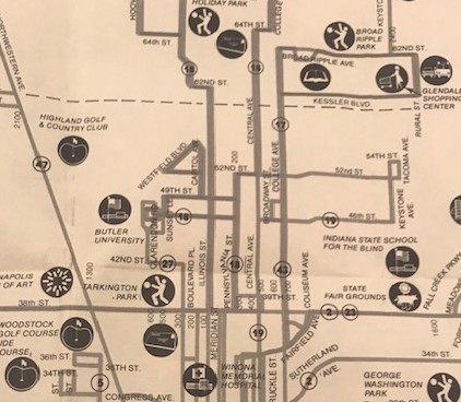
The 1940 transit map (see excerpt below), shows the Butler street car line in red, along with the bus route in green, with its loop through campus. The Route 4 streetcar line does not appear on this map, but a suburban cross town feeder bus line was in place, represented by the broken green line which ran along Westfield Blvd. The full digital version of this map may be viewed here, as part Indiana Historical Society's digital images Bicentennial Collection.

Butler-Tarkington continued to be served by the Butler streetcar line and motor buses, up until the early 1950’s when the streetcar lines were retired. The Broad Ripple streetcar line, which now ran all the way up College, was the last streetcar line in the city to be retired in January 1953. The Butler line was retired before that, and references in the Indianapolis News from September 1951 note that at least some of the decommissioned street car rails from the line, which had been taken up during the conversion to trackless trolleys, were donated to the national scrap metal effort related to the Korean War. The photo below from the IHS's Bicentennial Collection, shows the number 3 Illinois - Butler Streetcar, likely on the turnaround loop on Butler's campus (photo is dated 1949, just before the end of the streetcar service). It appears the building in the background right is Jordan Hall. Note the red paint on the streetcar which corresponds to the color of the streetcar line in the map above.

Not all the rails had been taken up, and some remained in place to provide "negative return for the new trackless trolleys. The trackless trolleys had the same route in the neighborhood as the streetcar, except the route went from 42nd to Clarendon and then north toward Butler, discontinuing the original campus loop route. The bus route up Capitol also remained largely the same.
In 1973 the city council-created Metro Transit (the formal name of which was Indianapolis Public Transportation Corp.) which took over transit operations in 1975, and by the 1980’s the gasoline powered buses were the only vehicles being operated by Metro Transit, the trackless trolleys having been retired in 1957. By the early 80’s, Butler-Tarkington was served by two bus lines, the 27 and the 18. The 27 followed a route similar to the old streetcar and trackless trolley, with the route going up Clarendon and turning around on Butler’s campus. The 18 bus route in the neighborhood was similar to the old A bus route, but it also continued north, to the northside of the city. The map below is a circa 1981 system map for Metro, maintained with the transit clipping file a the Indiana State Library. The black and white map made tracing some routes difficult.


In 1996, Indianapolis Public Transportation Corp. did away with the Metro moniker, and adopted IndyGo as the name of the transit system. The routes in Butler-Tarkington remained mostly the same, with the focus of routes being the Butler campus and connections to the northside. By the early 2000’s decreasing ridership resulted in the elimination of bus traffic directly to the campus, and a decrease in service.

At one point in the middle of the 2000’s, Butler-Tarkington was served only by the 28 bus, which ran north and south along Illinois street, and the 38 bus which ran along 38th Street. Neither made any deviations farther into the neighborhood. (photo to the left, compare with the 1981 map above) Later changes including routing of some buses back down Boulevard. Presently, the neighborhood is served by the 18 and 28 buses, both of which follow the same route through the neighborhood (down Illinois with stops on Butler’s campus via 46th and 49th Streets), but then split to different areas at Westfield Blvd. and the canal. Following the upcoming changes to the IndyGo system, the 28 bus will continue to Butler, but the route will go up Boulevard, cut west to Butler via Hampton, and then return to Illinois to continue its route to the north side.

The modern buses which serve Butler Tarkington are readily apparent as they move up and down Illinois and make their loop at Butler, but signs of the old streetcar and trackless trolley days are long gone. The streetcar loop at Butler was replaced by the parking lots behind the new Irvington House dormitory. The overhead electrified lines which provided power to the streetcars and trolleys are gone, although there is a structure (photo at left) near the intersection of Boulevard and 38th Street which may be a relic of the overhead wiring used by the cars and trolleys. It is unclear whether this is related to the old transit lines, or something completely different, but it is the only such structure in the neighborhood. The remains of the tracks used by the street cars likely still reside under several layers of pavement around the neighborhood, despite the report of them being removed for scrap. As the construction on the Redline along College Ave. revealed, there were still plenty of streetcar rails being removed the length of College. Plans to repave Clarendon Road from 38th Street to Butler's campus later this year may reveal leftover tracks from the Butler streetcar at the intersection of 42nd and Clarendon.
References
Image and map citations as noted above.
Encyclopedia of Indianapolis, Fairview Park, Indianapolis Public Transportation Corporation.
Indianapolis Star, February 20, 1933, January 1, 1953, September 6, 1986, November 8 and 12, 1996
Indianapolis News, September 21, 1951
Butler Collegian, October 16, 1951


Comments