From 38th Street to Maple Road and Back Again
- Sep 3, 2025
- 6 min read
Note: A version of this post will appear in the upcoming fall issue of the BTNA Newsletter.
38th Street is one of the most prominent roadways in Indianapolis and stretches nearly across the whole of the city and Marion County. In the early years of Indianapolis there was no 38th Street, and the area along its future route was primarily agricultural with few established roadways. Michigan Road, a state highway, was a significant north/south artery, made more important because of its bridge over the White River, while Illinois Street was only an improved gravel road. The future 38th Street was the boundary between Center and Washington Townships, and by the mid-1850s, a roadway along the present-day 38th Street (yellow highlight in the map below) existed between Michigan Road, also known at this time as Northwestern Avenue, and Illinois Street (green highlight). Within the next ten years, the roadway would be extended eastward to Central Avenue (purple highlight), which like Illinois, then existed as significant north/south street.

Sections of the future 38th Street continued to be added, with the roadway being extended nearly to College Avenue on the east. While the area along 38th Street would remain outside city limits for another few decades, in 1889 the roadway received a city number and was identified as 32nd Street. Within a few years the numbering changed again, and the roadway was designated 30th Street, before the 38th Street designation was applied in the late 1890s.

In the first decade of the 1900s Indianapolis was embarking upon a plan to construct new parks and a series of specially designated boulevards, which would be landscaped and under the control of the Parks Board. The system was planned by renowned landscape architect George E. Kessler and in 1909, a map was published showing the various parks and boulevards in Kessler’s plan. While 38th Street, then the northern boundary of the city, is identified on this map, it was not included in the Parks Board’s plan. Kessler noted in a report to the Park Board in 1909 that “[i]t is important that an outlying boulevard and parkway scheme at the outskirts of the present city limits should be projected and acquired in the near future and before the possibilities are largely limited by the advance of private improvement.”
Included among these “outlying” boulevards referenced by Kessler was 38th Street, and in 1911, the Park Board gained control of the roadway. The board also obtained a stretch of land on either side of the roadway to allow for landscaping and other improvements along the stretch of road from Michigan Road to Capitol Ave. Finally, the new boulevard was renamed Maple Road, a likely nod to the village of Mapleton located at the roadway’s intersection with Illinois Street, and the sugar maple groves which had been prominent in the area.

At the end of 1911, work had begun on the boulevard conversion along 38th Street / Maple Road between Northwestern and Capitol Avenues, including the installation of new curbing, gutters, and laying of a macadam roadway surface. Overall, the Park Board had a 100-foot-wide right-of-way, with the roadway being 40 feet wide with an additional 30 feet of sidewalk and landscaping on each side of the road. The image below, from spring 1911, is from the Indy Parks architectural collections at Ball State and shows a cross section of the proposed roadway of what was then still being called the "38th Street Boulevard."

Trees were also planted along the route, including, appropriately enough, nearly 600 sugar maples. The image below shows a stretch of Maple Road between Michigan Road and Boulevard, looking east. Crown Hill Cemetery is on both sides of the road, and the much-abused brick and wrought iron fence around the cemetery is visible. Note the newly planted trees on each side. Today 38th Street has been expanded so the buffer on each side is limited to a sidewalk.

As described by Kessler at the end of 1911, the planned improvements along Maple Road would “entirely change the character of the northern district,” and that “a wide driveway through that section, with its avenue trees and broad grass spaces on the sides, has already stimulated fine residence improvement, and has very greatly aided in increasing the values of all the land in that entire district.” The work was completed in 1912, and the new boulevard was opened on October 2, 1912. The Park Board reports around this time included a series of 'then and now' photos for Maple Road. The images below, from a 1912 report, are looking west from the intersection with Capitol, towards Boulevard Place and Crown Hill. Some of the homes on the left of the post improvement image (right) still stand today.

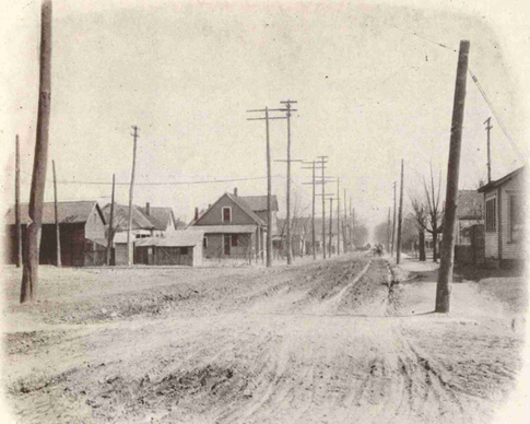


The stretch of Maple Road between Capitol and Fall Creek Parkway (just past the State Fairgrounds) was completed in 1914, in the same style as the first section in 1912. Sticking with the “maple” theme, hundreds of sugar maples were also planted along the route. In his annual report to the Park Board highlighting park system improvements, Kessler pointed to Maple Road as an example of the progress that year. “The recent completion of the Maple Road strikingly illustrates one element of this improvement—a broad, dignified, handsome highway; a street, in fact, only better than the average city street by reason of its greater width, symmetrical and consistently uniform improvement....”. The image below shows a 'before and after' view of Maple Road looking east from Central. The brick building on the left side of each image is a fire station, which still stands today.

Another view of Maple Road, this time looking west from Central Avenue towards the Illinois Street and Mapleton is shown below. The church steeple in the distance on the right side of Maple Road is the Mapleton Methodist Church.

As part of the maintenance of the boulevard, the Parks Board banned heavy traffic from using the roadway. This proved impractical, and some representatives from local ice, oil, and coal companies objected that their vehicles needed to use the roadway to deliver to their customers. Exceptions were made, although the park board warned that they would monitor use in case heavy vehicles were using Maple Road more than they needed to.
Exceptions also began to be requested for businesses to be located along Maple Road, which had previously only been planned for residential lots. A large amount of commercial development along the route did not play into the boulevard scheme, and some businesses, including a gas station on the corner of Capitol, were denied. However, following Kessler’s death in 1923, the boulevard focus began to crack. In 1933, the responsibility for Maple Road was transferred from the Park Board to the Board of Public Works. The rationale was to “provide protection for the street against undesirable types of businesses,” although after the transfer, commercial and business development became more common. Jackiel W. Joseph, the president of the Park Board, was quoted by the Indianapolis News as claiming that the street “in reality had ceased to be a boulevard and was a business street.”
The “Maple Road” name continued to be used, although “38th Street” began a resurgence in popularity. The “38th Street” name had never really gone away, but it became more common in the 1940s. Apartment advertisements in the mid-1940s for rentals along Maple Road gave the location as “38th Street (Maple Road).”

Over the years since the boulevard status fell away, the roadway has been widened, erasing much of the park-like buffer installed under Kessler’s direction. In 2005–06, new medians were installed from Michigan Road to Central Avenue. These medians included large planters, decorative stone bowls, and a maple leaf branding, giving something of a throwback to the boulevard history of the route. In 2016, the intersection of Illinois and 38th Street, dubbed “Maple Crossing,” a reminder of 38th Street’s past, was named an Indianapolis “Great Places 2020” location. The old flower shop at 38th and Illinois, shown below, was branded with Maple Crossing graphics.

Sources
Indianapolis News: March 24, 1911, April 30, 1915, May 19, 1915, November 2, 1933
Indianapolis Star: April 11, 1943
Report of the Board of Park Commissioners for 1911, Indianapolis Public Library, https://www.digitalindy.org/digital/collection/ipr/id/99246/rec/1
Report of the Board of Park Commissioners for 1912, Indianapolis Public Library, https://www.digitalindy.org/digital/collection/ipr/id/35427/rec/50
Report of the Board of Park Commissioners for 1914, Indianapolis Public Library, https://www.digitalindy.org/digital/collection/ipr/id/122401/rec/22
Report of the Board of Park Commissioners for 1915, Indianapolis Public Library, https://www.digitalindy.org/digital/collection/ipr/id/131459/rec/102
38th Street (Capitol to Fall Creek) drawings, Andrew Seager Archives of the Built Environment, a Division of University Libraries https://dmr.bsu.edu/digital/collection/IndplsPDArc/id/6660/rec/11
R.L. Polk & Co.'s city directory map of Indianapolis, Ind., Indiana State Library,