Then and Now: The Intersection of Senate Avenue and Washington Street
- Apr 28, 2022
- 8 min read
Updated: Jun 4, 2022
The early years of Indianapolis are documented only in descriptions and a few very old photographs. Other images of the city in its first few generations are provided in the sketches of Chirstian Schrader, whose works were compiled by the Indiana Historical Bureau's 1987 book, Indianapolis Remembered: Christian Schrader's sketches of early Indianapolis. Several of Schrader's other sketches have been featured in past posts to this blog including the West Market, the National Road Bridge, and the Central Canal lock at Market Street.
Another of Schrader's sketches caught my eye because of its perspective on a scene I have seen many times since my day job is near location depicted. The scene below is the image by Schrader and shows the intersection of Senate Avenue (then called Mississippi Street) and Washington Street, as seen from the southwest corner of the statehouse lawn looking towards the southwest.

That same scene as it appears today is shown below. The opposite corner is now occupied by the Old Trails and Fair Buildings, while the northwest corner is occupied by the Indiana Government Center South. The southeast corner is now part of the Westin Hotel property.

Schrader’s sketch shows a much different, and less developed scene of a time when Indianapolis was still in its first few decades of existence. The exact date the sketch is supposed to depict is not known, although Schrader’s sketches were done later in his life, based on his recollections of his youth in Indianapolis during the 1840's and 1850’s, and there are dates noted next to some structures in the image. The sketch contains information about the environment, and those living in it, although when viewing the images, we should keep in mind that Schrader's memory might not have been perfect. Despite this, these sketches provide valuable information about a period of Indianapolis history which pre-dated frequent use of photography.
Exploring this specific sketch, we'll first start on the southeast corner of Mississippi and Washington Street, which Schrader notes is occupied by “dog fennel.” Dog fennel was a common invasive at the time, not unlike our honeysuckle today, and it had some toxic properties, and was known to cause illness in some animals. The plant spread quickly in early Indianapolis, and newspapers would occasionally comment about its prevalence and the need to control its growth. On July 15, 1848, the Locomotive was bemoaning the lack of development between North Steets and New York Street in Indianapolis, noting the paper's belief that this section of city was "more desirable than any other for handsome dwellings" but that most of the area was an "unfenced common, overrun with dog fennel." In 1845, the Indianapolis Indiana State Journal referred to the invasive as "our universal dog fennel." The commentary to this sketch in the Indianapolis Remembered : Christian Schrader's sketches of early Indianapolis, noted that the town passed an ordinance requiring that property owners keep the weed in check.

The opposite corner from the statehouse lawn contains three homes, two of which have late 1840 dates. The first home is identified as the home of "Nicolai." According to the text accompanying the sketch in Indianapolis Remembered: Christian Schrader's sketches of early Indianapolis, Nicolai was a family from Germany, and the patriarch, Louis, owned a meat store on Washington Street. The earliest city directory is from 1855, and no Louis Nicolai was located, although a Julius Nicolai is in the directory, with an occupation of grocer, and a place of business on the south side of Washington Street between Mississippi and Tennessee (Senate and Capital today), just out of frame to the left in Schrader's sketch. A Julius Nicolai also appears in the 1850 census, with an occupation of merchant. It appears Louis and Julius are the same person and based on an ad from the Indianapolis Indiana State Journal on June 22, 1847 (pictured), he was a merchant and involved in grocery and dry goods sale. The location was on the stretch of Washington Street just east of the scene depicted in Schrader's sketch. In April of 1851, Nicolai announced that he had sold his grocery and dry goods business:

The sale was to B. Weide & Co., and Nicolai thanked his customers for their years of patronage, while also reminding those who owed him money, and those who may have had claims against him, to present these debts and claims to him. In the years subsequent to the sale Nicolai was also active in local Democratic politics, although it does not appear he returned to the merchant business.
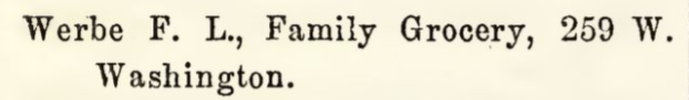
Right on the corner of Mississippi and Washington Street, roughly where Loughmillers Pub would be today, is a frame home which is Schrader labeled as a "country store," although the name is not clear due to a smudge. The accompanying text for this sketch indicates that the mystery name is Werbe, and the property belonged to Louis F. Werbe, at least as of 1849. This individual is also likely Ludwig Ferdinand Werbe, which reader Sharon Butsch Freeland informed me was a more traditional spelling of the Americanized Louis F. Werbe. References for Werbe were somewhat limited in local sources. The 1855 city directory notes that he is the secretary of a local German club, although no entry is made for his home or business. The 1857 city directory reports Louis F. Werbe to be operating a grocery at the corner of West and Washington Streets, a few blocks west of the Schrader sketch location. However, in 1860 his residence and grocery is located at 185 W. Washington Street, roughly near where Missouri Street is (street numbering was different then), while in 1865 his "family grocery" is identified as being back at 259 W. Washington Street (below). The 1867 Logan Directory identifies an F.L. Werbe residing at 249 West Washington Street.
Wherever Werbe operated, it is clear he had a grocery along Washington Street at various times in the 1840-1860's. How accurate Schrader's sketch is to the location in 1849 is hard to judge, as he was only seven years old at the time, but I think it is safe to say he was correct about the area where Werbe lived, and operated his grocery.
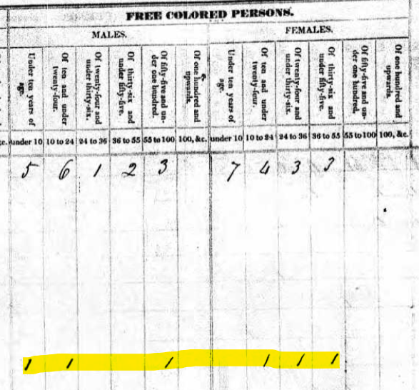
A little way west on the southside of Washington Street is the Overhall residence, which Schrader identifies as a "colored" family, but includes no date. It appears Schrader may be referring to the Overall family, a prominent African American family in the area who first moved to Indianapolis from Corydon in the early 1830's. Based on the 1830 census for Indianapolis, the Overall's were already residing in Indianapolis, although their specific location is not indicated. The census record below shows the name of James Overall, the family's patriarch, on the left, and the members of the household on the right.


James Overall was well known in African American community in Indianapolis, not only for his property holdings in the town, but also his position with the Indianapolis AME church, and his work assisting escaped slaves whose routes to freedom took them through Indianapolis. He later purchased large amounts of land in Hamilton County, and he was the subject of a noteworthy early legal matter. While residing near the intersection of West Street and Indianapolis Avenue in March of 1836, Overall and his family home were accosted by a gang of white individuals, according to some sources, workers then engaged on the construction of the National Road. In defense of his family and property, Overall shot and wounded one of the gang members.
This incident launched legal case which challenged the legal rights and standing of free blacks in Indiana to defend themselves, and to offer testimony against a white person. The story behind this matter is worthy of a blog post all its own, but others have already tackled that. The Indiana History Blog has an excellent post about this event, which can be accessed here. The Indiana Historical Bureau also has a webpage detailing the history of this event, and highlighting a historical marker erected near Overall's property on Indiana Avenue. That page may be accessed here and is a great resource which provides a lot of detail about Overall and his family outside of the incident at his home (make sure you read the annotations on this page!). The historical marker is located at the intersection of West and Indiana Avenue, on the west side of West Street and is pictured below.


It is not clear what date is associated with the Overall home in Schrader's sketch. Only a few mentions of the Overall family (again, sometimes referred to as 'Overhall') are made in the early Indianapolis City Directories (the first of which was published in 1855), and a notice of the death of a James Overall was reported in the Indianapolis Indiana State Journal on December 8, 1846. The notice indicates Overall's estate was to sell land located in Hamilton County on the first Monday of January 1847 in Indianapolis, and that Overall was "late of Marion County."

On the right side of Schrader's sketch, the northwestern corner of Mississippi (Senate) and Washington Street, was property owned by William Vanblaricum (sometimes spelled as Van Blaricum) or "Bill" as Schrader referred to him. Vanblaricum and several relatives were early residents in Indianapolis, and owned property and various business interests throughout the area. William also served as a town councilman for the Indianapolis 6th Ward in 1845 and 1846. In this role he was involved in a number of community improvement projects, including the building of a bridge over Pogue's Run at Alabama Street, and the digging of wells at the east and west market houses (see the clipping from the Indiana Democrat), both projects which were being put out for bid in spring of 1846.

This lot depicted in Schrader's sketch is now occupied by a portion of the Indiana Government Center South, and Schrader does not appear to have placed any structure on the corner. However, the property was far from empty, and in June of 1848, the Locomotive reported that Vanblaricum had "erected a large frame building, to be used as a carriage shop, a steam sawmill, and a turning shop-although the sawmill has been in operation some weeks the building is not yet finished." Vanblaricum appears to have run into financial and legal trouble in the early 1850's, and over the course of a few years several notices are found in local papers reporting on various sheriff sales of his property around the city in order to satisfy several judgments levied against him. Included with these properties were lots adjacent to the National Road Bridge, and adjacent to the canal's outlet along the river, both locations which would be important manufacturing and industrial sites in the future.
The Senate and Washington Street corner has changed significantly over the years. Part of this was from the name of Mississippi being changed to Senate, and the other from the growth of the city. Finding an image of this intersection between today and when Schrader sketched it is difficult, although I did find a wide view image of the statehouse which included the intersection from 1896.

The Senate/Washington intersection is on the far left, and a close up of that area is pictured below. Today, Senate is no longer a complete street as depicted by Schrader or in this image, and ends in a short parking lot adjacent to Loughmiller's Pub.

Sources
Indianapolis Locomotive: June 3, 1848, June 3, 1849, June 6, 1849
Indianapolis Indiana State Journal: August 27, 1845, December 8, 1846, June 22, 1847, April 24, 1851
Indianapolis Indiana Democrat: May 29, 1846
Indiana State Sentinel: October 7, 1852
Schrader, C. (1987). Indianapolis Remembered : Christian Schrader's sketches of early Indianapolis. Indianapolis, Ind.: Indiana Historical Bureau.
Logan's Indianapolis Directory, Embracing an Alphabetical List of Citizens' Names, Gathered and Compiled Expressly for this Work (1867), https://indianamemory.contentdm.oclc.org/digital/collection/ICD/id/39684/rec/11
A. C. Howard's Directory for the City of Indianapolis (1857), https://indianamemory.contentdm.oclc.org/digital/collection/ICD/id/35359/rec/2
The Indianapolis City Directory for 1865, https://indianamemory.contentdm.oclc.org/digital/collection/ICD/id/36085/rec/3
James Overall: Indiana Free Person of Color and the “Natural Rights of Man”, Indiana History Blog, https://blog.history.in.gov/james-overall-indiana-free-person-of-color-and-the-natural-rights-of-man/
James Overall, Indiana Historical Bureau, https://secure.in.gov/history/state-historical-markers/find-a-marker/find-historical-markers-by-county/indiana-historical-markers-by-county/james-overall/?a=212941
Aerial View of the Indiana State Capitol Building Looking West from the Top of Monument Circle, 1896, Indiana Historical Society, https://images.indianahistory.org/digital/collection/dc012/id/14269/rec/5


If you say "Julius" with a German accent it sounds like "Louis" to one that speaks English. It's the same issue of Dutch immigrants named Klaas, to an English speaker of the time, it sounds like "Carlos".