The History of the Former DeHaan Estate Property in Indianapolis
- Dec 20, 2023
- 10 min read
Updated: Feb 26, 2024

There has been much media attention of late about the opening of the Restoration Hardware location on Michigan Road in what was once the estate of the late businesswoman and philanthropist Christel DeHaan. She passed away on June 6, 2020, and the 150+ acre property, bound by the White River to the east and south, Michigan Road to the west, and the northern bluff of the White River valley, was subsequently sold for just over $14 million. While other local institutions were rumored to have been interested in the property, it was sold to a development company and the large home on the property, which was called “Linden House,” was leased to high end furniture retailer Restoration Hardware for use as a showroom/restaurant.
So, let’s explore this property before it became a spot where you can purchase a $32 dollar moderately sized piece of salmon and/or a $5,000 rug. Below is an aerial of the property as it appeared earlier this year. Christian Theological Seminary is at the bottom. Michigan Road is the large roadway bisecting the image.

To go way back before Indianapolis or even Marion County existed, the property and the surrounding land was occupied by a variety of Native Americans, including the Miami and Lenape. The Lenape were the primary group in this area, although their population center was along the White River farther upstream in Hamilton and Madison Counties. This post provides more detail about the Native American presence in this area immediately before Indianapolis was founded.
During the initial land sales once the territory in Marion County was open for Euro-American settlement, the first person to purchase land was William Sanders. The land was mostly located in northwestern quarter of Section 15 of Township 16N Range 3E. A smaller part is located in the southeastern corner of Section 10, just to the north. However, many of these first purchasers were speculators, who sold the land off, or would later lose the land due to financial hardship or other causes. The property had potential. Being adjacent to the White River provided the possibility that the river’s power could be harnessed for industrial purpose, including possible milling operations. The hope that the river would be a commercial waterway was also still possible, although this later would prove limited.
The property took on an added value when the Michigan Road was surveyed and constructed along its western boundary in the early 1830s. Not only an avenue for commerce, but the road later resulted in one of the few bridges being constructed over White River north of downtown, which would attract travelers, domestic and commercial, from around the area. Also, around this time, the property became adjacent to the proposed town of Mt. Pleasant which was to be situated on the bluff on the northside of the river, and adjacent to the Linden House property. Some maps, including the 1855 Condit map (pictured later in this post), show the town as being laid out directly north of the river, and at the Linden House property. However, descriptions, and later maps, identify the town as being a mile north, at the top of the ridgeline just north of the river.
An advertisement in the Indianapolis Journal from October 21, 1837, announces the sale of lots in the proposed town of Mt. Pleasant. Joseph Andrus, the person who placed the ad, also noted that he was holding a “private sale” for 250 acres of “first rate land adjoining the town and fronting on the Michigan Road ½ mile and laying between the road and the river; the river being the east line.” This describes the Liden House property. The advertisement promotes the land as one of the “most desirable tracts of land in Marion County,” and that there were around 50 never failing springs on the land in addition to the water rights from the river. There is also a mill seat on the property, along with a site for a potential distillery. A ‘seat’ was simply a site which could be used as a location for a water powered mill and would have included a possible location for a mill dam and if necessary, mill race, to direct water to the mill. The advertisement notes that “[t]he river when damed[sic] will afford a large abundance of water for all kinds of machinery.
It is unclear whether a mill was ever opened on the site. The river to the east of the Linden House land does include a significant drop, and the remains of what I had thought might be an old mill dam. There is a large amount of rock in the river, which pools the water upstream. Additionally, as seen below, there is the remains of a rough rock wall built into the eastern bank which appeared to have once extended into the river. Over the years more rocks have been exposed from this structure as the bank has eroded from natural processes and from people hiking and climbing along the area, and additional rock can be seen still partially buried. I have never found any source to confirm there was once a mill in this area.


The Linden House property went through a variety of owners over the course of the next 50 years, and seems to have remained in a natural state, or used for agriculture. The low ground, especially on the south end of the property, likely flooded during high water events, which would have limited any additional development of the site. The map images below show the property in the 1855 Condit map, 1866 Warner map, and 1889 Atlas of Marion County. Note the change in position of the pat for the town of Mt. Pleasant between the 1855 and 1889 maps.


In 1901 the property was owned by Peter Sindlinger (see Baist map below). Sindlinger had worked in the retail meat business in Indianapolis, and had been heavily involved in Democratic politics prior to his death from Typhoid Fever on December 7, 1903. Note that the town of Mt. Pleasant is laid out, but still has few buildings in 1901.

The property changed hands a few more times in the in the next 30 years, including being owned by a local bank. From the 1940s onward, the property was owned by Samuel Harrell, an executive with General Grain, Inc., and the Acme-Evans Company. Harrell operated the Valley Forge Farms Registered Angus cattle ranch on the property, in addition to two additional sections of land, each of 80 acres, which he rented from Butler University (I'm unclear where these were located. Possibly on the Rocky Ripple side of the river). As of 1965, Harrell had 150 head of cattle on the ranch and he also owned farmland at Stoney Creek in Hamilton County. Some sources note that a dairy farm was operated on the land during this time, although as of the 1960s Harrell was just using the land for cattle.
In 1966, the land took a turn away from purely farm related pursuits, when St. Maur’s Benedictine Monastery announced plans to construct a new monastery and seminary on the land. The monastery was based in South Union, Kentucky, and was looking to relocate to expand its ministry to an urban area while emphasizing diversity amongst the clergy and the church, and to promote an interracial religious community. The proposal to move to Indianapolis was initially made in January 1965, and several sites around the city were examined. One site which was seriously considered was the purchase of the land where the Major Taylor Velodrome stands today. However, the upcoming construction of Interstate 65 through the property derailed this. The Harrell ranch site was also considered and finally in November of 1966 the move and purchase of the property, which totaled over 176 acres, was finalized.

The monastery opened with a small complex of building located near the north end of the property on top of the bluff, with most of the rest of the land being left in a natural state. The image above, from the African American Catholics of the United States collection at the University of Marquette, shows a barn left from the property's prior history which was used as a chapel when the monastery first opened.
A portion of the monastery land was also leased to Allied Aggregate Corporation for the mining of gravel, a common occurrence along the White River in central Indiana (re: the lake in the oxbow at Broad Ripple, and the lake at the Newfields/Museum of Art property.) Starting in 1968, the company began excavations, with the gravel being used for the construction of nearby Interstate 65 for its route through the city. This project resulted in some homeowners near the St. Maur property losing access to water when their wells ran dry as a result of the large gravel operation. The aerial images below show the property in 1966, and in 1972 when the gravel operations were nearing an end, and the lake is nearing completion.


The lake, sometimes referred to as Lake Maurwood, was used by the monks at the monastery and by members of the community for recreational purposes for a small fee. The land was still used for some agricultural purposes, including as an outreach effort for city teenagers who maintained crops on the property, with the crops being for personal use, and some being sold. Garden plots could also be rented from the monetary for use by members of the community. Day camps were also hosted at the property, as were retreats, corporate events, and dances at a lakeside pavilion. The monks at the monastery also maintained an outreach center in downtown Indianapolis and launched the Institute for Race and Religion at the monastery.

St. Maur’s Seminary, also called Catholic Seminary of Indianapolis, hosted regular classes at the location right across the White River from the Christian Theological Seminary. The proximity to the two religious schools brought attention to the area as a hub of religious study and a cooperative agreement was established between the two schools. There was even discussion about the construction of dormitories for CTS on the CSI/St. Maur property. However, enrollment at St. Maur peaked in 1974 with just over 20 attendees, and never seemed to expand beyond this, closing a year later. By the early 1980’s not only was the seminary closed but the number of monks residing at the property had also declined until the Indianapolis Star reported in 1981 that four monks remained living on property. The downtown outreach center had also ceased its efforts. For money to maintain operations, the monastery continued to rent out its facilities on the property for events and public use which continued through the rest of the 1980s and the 1990s.
During the summer of 2001 the St. Maur monastery was sold to philanthropist and former timeshare mogul Christel DeHaan. DeHaan’s property on the eastside of Michigan Road totaled in excess of 170 acres, and she indicated plans to develop the land to construct a home for herself, and a limited number of additional homesites for family and friends.
The plan was controversial and several grassroot groups organized to oppose the development, advocating for the land to be kept in a natural state and possibly as a park. The groups cited past use of the land by the public for swimming, fishing, and recreation, and that the site was “one of the last undeveloped green spaces in the heart of Indianapolis and is critical part of a large riparian tract of the White River…”. During a meeting with neighbors and community groups DeHaan and her representatives were questioned about public access, and noted that the St. Maur property had been private as well, and was never public, although the public had been permitted to use it. A regular at a bar I frequent near my home told me he would often run his dogs on the property, and that while it was private, the monks often didn't have issues with the public coming on the property. In terms of DeHaan's use, one representative noted that as to the future of the property, "Will it have public access? The answer is no."
Other concerns, especially environmental, were also noted, as were potential issues if flood control work was done on the property. A large portion of the land was a flood plain and was impacted during high water events. Protecting the lower portions of the property from flooding could potentially push water upstream, impacting other communities. DeHaan's proposed use received support from some local neighborhood groups and eventually moved forward, although only a few homes were ever constructed at the site.
During the fall of 2001, while the controversy with DeHaan’s planned development continued, the site was also considered as the location for a new residence for the Governor of Indiana. State officials had been looking at whether to renovate the existing residence at 46th and Meridian or construct a new home. The St. Maur site was considered, as was a site at 24th and Meridian, and at Fort Benjamin Harrison. Local media reported that DeHaan did not offer any land at site for sale, and in the end the existing governor’s mansion was renovated and remains as the governor’s home to this day.
DeHaan constructed a massive wall along the property’s frontage on Michigan Road, and also constructed a gigantic mansion for herself on the shores of the gravel pit lake. Not visible from Michigan Road, the home was visible from the Canal Tow Path and from the Chistian Theological Seminary property, especially during the fall and winter.

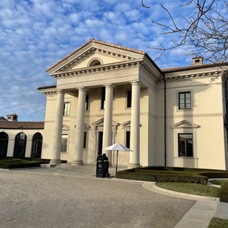
In 2022 the land and house were purchased by Linden House Indiana Holdings, LLC, a development company based in Aspen, Colorado and not surprisingly, incorporated in Delaware. The mansion on the property was leased to Restoration Hardware, which uses the home as a show room and restaurant. The property is impressive with several art pieces still in place around the grounds and the grandiose (maybe Roman-esque?) Linden House. When I recently visited the home was attracting a lot of curious visitors, including myself, although I had also made a reservation for lunch at the restaurant. Lunch was fine. My past jobs as a restaurant server have made me loath to critique restaurants and service, but while the latter was very good, the food portion was quite small for the price. The home was impressive, as were views of the property, although the home just seemed out of place for where it sits. It was very popular with folks on social media, and there were numerous selfies being taken and people staging Tik Tok and Instagram posts inside and outside the home as we wandered around. Additional future uses for the property remain to be seen.


Sources
Indianapolis News: January 29, 1965, December 7, 1903, June 28, 1966, October 28, 1970, September 24, 1980
Indianapolis Star: August 8, 1965, July 18, 1981, October 11, 1981, July 12, 2001, September 6, 2001, October 10, 2001, November 1, 2001, February 13, 2002, July 21, 2003, June 14, 2020. September 21, 2022
Concerning National Black Catholic Theological Training Center, https://uindy.historyit.com/item.php?id=530367
Condit, W. &. H. (1855) Map of Marion County, Indiana. Cin. O.: Middelton, Wallace & Co., lithos. [Map] Retrieved from the Library of Congress, https://www.loc.gov/item/2013593172/
Warner, A., Worley & Bracher & Bourquin, F. (1866) Map of Marion County, Indiana. Philadelphia: C.O. Titus, Publisher. [Map] Retrieved from the Library of Congress, https://www.loc.gov/item/2013593173/
Br Howard Studivant, OSB, last surviving member of early interracial monastery, dead at 87, Black Catholic Messenger,
Temporary chapel at St. Maur's Seminary, Indianapolis, Indiana, 1969, Department of Special Collections and University Archives, Marquette University Libraries, https://cdm16280.contentdm.oclc.org/digital/collection/p16280coll2/id/172/rec/3