South Indianapolis: A Tale of Two Suburbs
- Feb 14, 2024
- 8 min read
Most people are familiar with the ring, or donut, of suburban communities which currently surround Indianapolis. Included among these are Carmel, Fishers, Zionsville, Avon, and my hometown, Greenwood. In the latter half of the 1800s, several suburban communities had sprung up well inside this present-day ring, and around the outskirts of a much smaller Indianapolis.
One of the first was North Indianapolis, an industrial town which was platted north of Fall Creek and along the eastern side of the Central Canal, and southwest of Crown Hill Cemetery. Some history about the industry in North Indianapolis can be found here. Another was West Indianapolis, centered on the west side of the White River, southwest of downtown. West Indianapolis was at first incorporated as a town in 1894. In 1897, the town was annexed by Indianapolis.
There was no East Indianapolis, although the eastside did have Irvington as an early suburb. No maps show any “East Indianapolis” town or neighborhood. However, there was a South Indianapolis, at least, in theory.
South Indianapolis was a two-part development, although neither was related to the other. The first would be constructed directly east of the University of Indianapolis. First platted in 1874, the neighborhood was a simple square, southwest of the intersection of what was then Shelbyville Pike, and National Avenue. Shelbyville Pike, also called Shelby Avenue, is known today as Carson Avenue. The excerpt below is plat of the town:

The area identified as South Indianapolis begins to appear on maps in the 1880’s and continued to appear as a far-flung suburb of city into the early 20th century. The image below shows Perry Township from an 1889 Atlas of Indianapolis and Marion County. South Indianapolis is identified in the northern section of the township, highlighted in green. Southport is located to the south. An enlargement of South Indianapolis also appears in the upper left-hand corner, although few structures appear to have been constructed at this point in history.

The development never filled out as much as its plat with numerous residential lots might have suggested. There were no trumpeted advertisements for the new development, although here and there references of land transfers within the South Indianapolis area are found in local newspapers. Even in 1901, when the “town” appears on the Basit atlas for that year, there appears to have been little development.


The first aerial photograph of the area in 1937 shows a mostly rural South Indianapolis, just next door to Indiana Central College. None of the cross streets contained in the plat appear to be in place at this point. Eventually Atlantic Street was cut all the way through, while a small segment of Pacific Street was also constructed. If you look closely at the second, modern, aerial image, you can see a vague hint of the right of way for Pacific Street, cutting through residential lots.


The second South Indianapolis was formally known as the South Indianapolis Industrial City. The development was located a bit farther to the west from the first South Indianapolis, near where Bluff Road crosses Lick Creek. The South Indianapolis Industrial City was described as a “factory suburb,” and had plans to not only include residential housing, but also land reserved for factories. The land for the factory suburb had been purchased from Allen M. Fletcher, the son of Stoughton A. Fletcher Sr., who in turn was Calvin Fletcher’s brother. Allen Fletcher operated several large farming operations on the south side of the city, most of which appears to have been inherited from his late father who died in 1882.
A company, the South Indianapolis Improvement Association, was founded in 1901 with the intent to develop the South Indianapolis site. A two-part plat for the new industrial town was filed in late 1901. The plat (pictured below, with both parts being merged) included residential lots, empty space for manufacturing concerns, and railroad access with space reserved for passenger and freight depots. A power plant was also planned to provide sufficient electricity to factories planned for the area. The planned suburb was something of an early 20th century version of a mixed-use development. The diagonal road on the right side of the plat is Bluff Road. The road on the far-left side pf the plat would be the present-day Harding Street. The diagonal line cutting through some of the residential lots in the middle of the plat is actually the former line of the Central Canal as it traveled through the southside of the city.

If you want to review a PDF of the above, which allows more zooming in on details than the versions above, a download link is available below.
On September 25, 1901, an Indianapolis News headline read “Factory Suburb” and extolled the virtues of the proposed town. Noting that “[t]he project for building a manufacturing suburb has at last taken such shape that the success of the plan, the promoters say, seems to be assured.” The development was planned to be 120 acres, divided into 24 factory sites, with the remainder being residential lots. The promoters announced several factories planned to move to the industrial town, and out of Indianapolis proper. The initial factories to move to the site would be given lots for free. The promoters expected to have 10 factories employing 2,000 workers in place by December 31, 1902, an aggressive goal for land which was still empty fields with minimal access to transportation infrastructure, although a rail line was planned to run through the middle of the development.
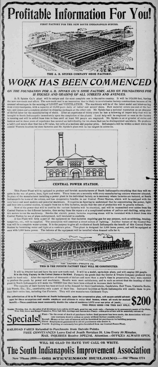
Shortly after the announcement of the new development, work began on two factories, a shoe factory being built by A. B. Spinks, and a factory for the Grever-Twaits company, a transplant from Cincinnati which constructed wrought iron artware and other metal art pieces. Newspaper advertisements trumpeted the new industrial town. One such page length ad appeared in the Indianapolis Journal on October 20, 1901. Under a heading that announced "Profitable Information For You!," the ad shows renderings of the proposed Spinks and Grever-Twaits factories, as well as a rendering of the future Central Power Station. This ad focused primarily on the industrial benefits of the proposed development, but also emphasized the living/working nature of the community, and the prospect for many more factories to join the industrial town: "The colonization of 10 to 50 Factories at South Indianapolis, upon the co-operative plan, will secure untold advantages for these enterprises and enable employes and citizens to enjoy ideal homes, where all work for mutual benefit." The ad also notes that housing lots were on sale for a one-day special price of $200.
Another advertisement on October 22 tried the guilt trip route to entice potential residents for the industrial city to visit the site and purchase residential lots. To further encourage prospective buyers the South Indianapolis Improvement Association promised to refund train fares for those traveling from outside Indianapolis, while transportation was provided from the south Meridian Streetcar line, whose terminus was a mile to the northwest of the development site.

Despite the optimistic outlook for the South Indianapolis development, signs that there may be problems began to arise. In late November 1901 it was reported that the Spinks and Grever-Twaits factories would not be completed that year, but instead would see further work pushed off to 1902. Part of the reason was the difficulty in bringing building material and workers to the site to work on the project. The News also ominously reported that the “efforts of the promoters are evidently centered on the factory buildings, and street work has been abandoned for the present.”
The lack of progress appears to have also impeded the residential side of things. The News further reported that there were no other buildings constructed on the site and that “[m]any people are waiting for the appearance of the first cottages. They will be needed for workmen of the factories. There are lot buyers who are ready to build as soon as someone else builds. They wish somebody to make the start.”
Aside from the middle school dance style standoff, where people are waiting on someone else to start dancing, the warning signs with South Indianapolis continued to mount. In December, Christopher B. Hermann, an advertising agent hired by the South Indianapolis Improvement Association to promote their project, filed suit for unpaid wages.

In early spring of 1902, the Association began to hemorrhage employees and investors. Several officers resigned, and the Association underwent two reorganizations. In May, the South Indianapolis Improvement Association defaulted on the mortgage for the industrial city's property. The mortgage was held by Allen M. Fletcher, who ordered his attorneys to take action on the default. A few days later on May 14, Thomas A. Fletcher, who had also owned some of the land purchased for the industrial city, filed a lawsuit in Circuit Court requesting that a receiver be appointed for the South Indianapolis Improvement Association. The associations' liabilities were estimated at $50,000, with $20,000 in assets. A visit to the Association's office in downtown Indianapolis by a reporter from the News found it mostly empty, with no leadership and few employees present in the office.
A Receiver, Howard Young, was appointed to oversee the failing Association, his first act being to find new office space for the failed company. He found the Association's offices were costing $75 a month, a high sum at the time, and was looking to relocate to a location in the $10 dollar range. Young obtained the books for the company and got back to work. The Indianapolis News reported hopefully that it was possible the residential sales in the now defunct industrial sale might still be able to move forward as the Receiver completed his tasks. In July of 1902 Young posted notices of a Receiver's Sale in local newspapers, scheduling a sale of the Association's assets. The sale would run from July 22 to September 10.
Allen Fletcher ended up regaining control of nearly all of the land which he had previously mortgaged to the Association. With land for the industrial city back in the hands of Fletcher, the former plat for South Indianapolis was returned to rural use. The Indianapolis News reported on May 2, 1903, that the site would be “a waving field of oats,” that season and that “fortunes were not made.” The News, waxing somewhat poetic on the situation, noted that aside from “a specter wreck or two of projected factories rise dismantled from the broken ground, there is little else to mark the greatest factory suburban project ever undertaken in this city.”
In the years after the proposed industrial city collapsed, the former site and the area around it became known for numerous greenhouses which sprouted up around the southside. Operated primarily by German immigrants, there is a historical marker on the far northeast corner of the former town site honoring these immigrants. The aerial image below shows approximately the same area as the original plat shown above.

Today, the only remnants of the South Indianapolis Industrial City are a few roadways, Sprague and Corliss Streets, which appear on the original plat of the town, and are visible above just to the left of the "Bluff Rd" label. The railroad which was planned to run through the town and into Indianapolis was later built and is visible bisecting the image above. The westside of the town plat is now dominated by trucking company facilities and warehouses, on both the north and south sides of Lick Creek. The eastside plat has more of a residential feel, although south of Lick Creek is a large greenhouse operation. A smaller greenhouse operation is on the northside of the creek, along Sprague Street. Perhaps there are some remains of the factories which were started and then halted located somewhere in this area, but that would be unlikely over a century since the industrial city failed.
Sources
Indianapolis News: September 25, 1901, October 15, 1901, October 22, 1901, November 23, 1901, December 11, 1901, May 14, 1902, May 16, 1902, May 2, 1903
Indianapolis Journal: December 11, 1901, May 17, 1902, August 9, 1902
Plat Images for South Indianapolis and South Indianapolis Industrial City accessed from Marion County Recorder's Office, https://www.indy.gov/activity/search-real-estate-records-online
Baist Real Estate Atlas, 1901, IU Indianapolis Library, https://iuidigital.contentdm.oclc.org/digital/collection/SanbornJP2/search/searchterm/Baist%201901/field/title/mode/all/conn/and/order/title/ad/asc


Comments