Redirecting Nature: Moving the White River
- Jan 10, 2024
- 6 min read
Welcome to the first post of 2024, and to celebrate a New Year, we’re going to return a frequent topic: the waterways of Indianapolis. Specifically, the White River. I’ve written so much about our city’s resident navigable waterway that it has its own page linked at the top of the blog. Check this link here to explore all sorts of river related content.
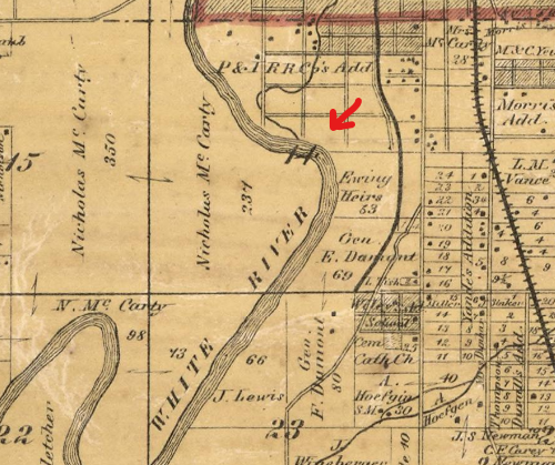
But back to the subject at hand. If one takes West Street south from downtown, it runs past Lucas Oil Stadium, under Interstate 70, across Morris Street, and then parallels the White River for a few miles before going under Raymond Street. The stretch of West Street between Morris and Raymond Street is interesting because the road was not always there. In fact, the land used to be occupied by the river itself. For the first 110 years of the history of Indianapolis, the White River took a turn to the east in a sharp bend at this point, before turning again and continuing south. Numerous maps show this bend in the river. The maps below are from 1855 and 1866, with the red arrows marking the bend.


Later, as more railroads began to be constructed into the city, several lines running from the southwest ran along the river bend on their route into the city. A large railyard was also constructed at the peak of the bend. The rail lines and yard are shown in the 1916 Baist Map below. Also shown is the original outlet of Pogue's Run, before the creek was rerouted farther north.

But then the course of the river was changed, although the remains of this bend in the river are still visible today. Modern maps and aerial images show this section of river is straighter than it appeared in old maps. However, just to the east of the river are the rail lines and the railyard (today owned by The Indiana Railroad) which outline the old bend in the river, an artifact of river’s former course. This is marked by the red arrows in the 2023 aerial image below. The rail line which runs across the middle of the image is the Belt Railway.

The river's course change occurred in 1930, but it was not a natural event. The change in the river's channel was completed when the local authorities sought to address flooding issues related to the bend, a component of the long running flood control plans which had been implemented in the years after the flood of 1913. New levees were also constructed along the newly redirected river section. The project was also part of a track elevation project for the Belt Railway which crossed through the middle of the river bend and included a new railway bridge and the removal of an old bridge. New boulevards were also to be constructed on both sides of the river. The project would result in a new channel for the river which was to be 650 feet wide with a depth of 33 feet. 33 feet had historical significance: It was the high point that the floodwaters reached during the flood of 1913.

To change the course, a new channel, the one present today, was dug to the west and parallel to the old river channel which ran close to the rail lines noted above. The Belt Railway line ran across this stretch, and while a new bridge for the railroad had been constructed over the new channel, the old right of way for the rail line formed an earthen dam across the entrance of the new channel to allow digging to continue, while the river continued to follow its old course. Once the new channel was done, water was allowed into the channel up to the point where the Belt Railway crossed, where the earthen levee which once carried the railway stood to prevent the water from flowing freely.
The opening for the new channel was scheduled for November 14. The construction firm in charge of the project, the American Aggregate Company, promoted the event as a spectator affair and sent invites to various local and state officials inviting them to the event and a post channel opening dinner. City officials would be in attendance, and Harry Leslie, governor of Indiana, was also scheduled to attend. The opening was to include the demolition of the levee/dam holding back the river from the new channel with dynamite. Described as “man’s triumph over nature,” the opening of the new channel was advertised to be opened “with a thunderous blast of dynamite” at 2:15 pm on November 14.
With the closure of the old channel of the river, the water levels upstream from the dam on the new channel were rising. Officials and workers on the project claimed that a “wall of water many feet high” would storm down the river when the earthen dam was blown. This fact was advertised heavily in local newspapers and resulted in a great deal of excitement for the event.
On the afternoon of the 14th, a huge crowd, estimated to be in the thousands, lined the banks of the river waiting for the explosion and the wall of water rushing downstream. At the appointed time, the spectators and honored guests waited with bated breath. The demolition charge, 300 pounds of dynamite, was set off, and made “a dandy noise,” but otherwise had no effect on the earthen levee aside from two puffs of smoke. As described by the News, “[t]he wall of water which was expected to come rushing through the new channel of the White River at the instant of the explosion remained a wall.” The failure of the dynamite was attributed to the fact that the dam had carried the Belt Railway for several decades, and the ground beneath it had been compacted and solidified over the years due to innumerable trains. The News, seemingly enjoying the fizzle of the event, detailed that “[t]wo craters were produced by the blast, but the new riverbed stretching nearly half a mile southward to Raymond Street, remained dry as the Sahara. The fill [the dam] stood like Gibraltar.”

And stood it did. With the failure of the dynamite, the workers on the project began to train high power water hoses on the levee (photo above, looking south towards the Raymond Street bridge), slowly eating away at the soil until finally it breached. Even then, there was no wall of water rushing downstream as had been advertised, but a slow trickle which engineers on the project estimated would take several hours before the flow of water cut a large enough gap to fill the new river channel. The spectators departed in a disappointed mood, the event not living up to the grandiose expectations set by those working on the project. As they departed, many found themselves stuck in massive traffic jam resulting from the thousands of spectators leaving all at once, and poorly planned traffic control by the American Aggregate Company and the city police, and the massive amount of deep mud in and around the project site. There is no word if the celebratory dinner was held or not. The old route of the river is marked in the Google Earth aerial below. Raymond Street is at bottom left.

Some sharp-eyed readers may have noticed in some of the maps above that there was another bend in the river just to the north of bend we've been discussing. This bend was at the point where Kentucky Ave bridge is located and just south the former Diamond Chain facility and Greenlawn Cemetery. The fate of this bend is less clear, although early maps of the city show a similar arrangement of roadways and rail lines along this curve after the bend stops appearing on maps.
It seems that the demise of that bend may have been related to mostly natural causes, specifically heavy flooding in 1883 and 1886 which redirected the river's channel. The 1886 flood was at the time called by the Indianapolis News and possibly the “highest flood in White River that has ever been known.” In the years after that event, the Kentucky Ave. bend is less pronounced and eventually disappears from maps. This bend is the marked by the green arrow at the top of the 1889 map excerpt below. The routing of rail lines around the bend's previous route can be seen just to the east of the river. The red arrow is the bend discussed in this post, while the second green arrow is a now disappeared bend which was located where the Lilly Recreational Park is located today, at Raymond and Harding Streets.

Sources
Indianapolis Star: November 14, 1930, November 15, 1930
Indianapolis News: January 5, 1884, May 14, 1886, November 1, 1930. November 12, 1930
Condit, W. &. H. (1855) Map of Marion County, Indiana. Cin. O.: Middelton, Wallace & Co., lithos. [Map] Retrieved from the Library of Congress, https://www.loc.gov/item/2013593172/.
Warner, A., Worley & Bracher & Bourquin, F. (1866) Map of Marion County, Indiana. Philadelphia: C.O. Titus, Publisher. [Map] Retrieved from the Library of Congress, https://www.loc.gov/item/2013593173/.
1889 Atlas of Indianapolis and Marion County, Indiana Map Collection, Indiana Division, Indiana State Library, https://indianamemory.contentdm.oclc.org/digital/collection/p15078coll8/id/1610


Comments