A Residential Island In the Valley Neighborhood
- Oct 18, 2021
- 5 min read
There have long been discussions on the impact of modern construction projects, like highways or stadiums, displacing residents of Indianapolis from long established neighborhoods, which themselves would subsequently be leveled in the name of progress. The interstate system cutting through Indianapolis is perhaps the most well known example of this, an issue which has been reignited with the reconstruction and expansion of Interstate 65 through the downtown core.
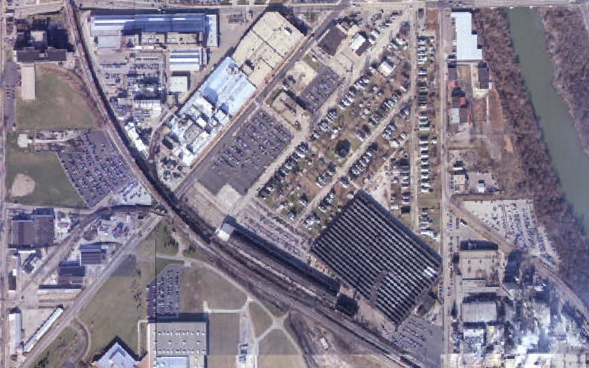
Business and education development can have the same effect, examples being IUPUI, Lucas Oil Stadium, and the Lilly Corporate Headquarters site. The latter entity has properties across downtown, and while researching the areas they occupy around the city, I came across a small corner of Indianapolis which is for all practical purposes, an island, surrounded by industry. The location is a remnant of neighborhood located adjacent to the Lilly Technology Center-North, a former industrial site, and the Belt Railroad. The Google Map image from below shows the neighborhood in relation to its industrial neighbors.

This neighborhood is part of a community which began to grow on the westside of the White River in the latter 19th century. When Indianapolis was first founded, the land was purchased by Nicholas McCarty, a successful merchant and land speculator who had significant land holdings on both sides of the river. After his death in the 1850’s, his son, also named Nicholas, inherited the land. Now known as West Indianapolis, the area was incorporated as a separate town in 1882 before being annexed into the Indianapolis fold in 1897. Like many neighborhoods, the boundaries can vary depending on the source you review. Usually, the eastern boundary is the White River, south is Raymond Street, north is the rail line adjacent to the former Chevrolet plant site, and west is Eagle Creek or Holt Road. Within West Indianapolis area are some additional area, including The Valley, which includes the area between the river and the Belt Railway, The Hill, which is the area to the west of the tracks. Two other areas are mentioned in sources, called the Hollow and the Bottoms, which occupied the southwest and northwest sides of the neighborhood respectively.
Going back to the neighborhood described above, even in the early 1900’s the area was still under the influence of the McCarty family. As shown in the Baist map below, in 1908 the land south and east of the neighborhood (red box) was still in possession of the McCarty family, or their heirs, although industry was common in the area.

The amount of industry would increase over the years. Interestingly, while the above Baist map shows no development on the southwest side of the property adjacent to the Belt Railway, the 1898 Sanborn map for the area shows that a foundry owned by the Nordyke Marmon Company, just to the southwest of the neighborhood (north is in the upper right corner on this map). However, the small print on the foundry notes that the structure was partially destroyed by fire, perhaps explaining why it does not appear in 1908.

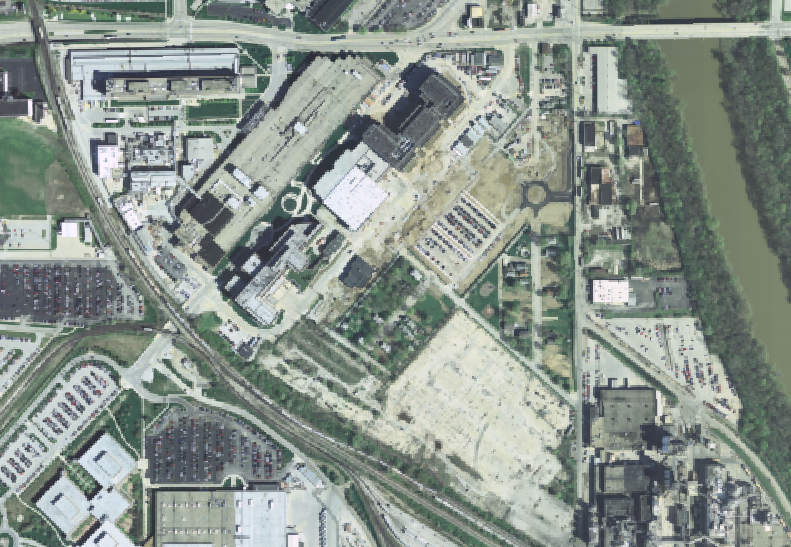
To the east of the neighborhood is a large empty field area, covered in pavement, except for several odd trailers parked throughout the property with piping that appears to be buried in the ground, and then directed into the trailers themselves. The image below shows this area, along with a few of the trailers. This view is looking west towards the neighborhood. York Street is to the right.

This site was also part of the Nordyke-Marmon Company's operations in Indianapolis. Originally a manufacturer of mill equipment (flour mills, etc.), the company moved to Indianapolis in the mid-1870's and occupied several sites in West Indianapolis. but branched off into constructing automobiles just after the turn of the century under the Marmon name. The auto plant occupied the site pictured above (identified as the "Marmon Motor Car Wks" in the Baist map below), while the mill manufacturing operations continued to the north, on property that today is owned by Lilly. Interesting note, Marmon constructed the first car which won the Indianapolis 500 in 1911, known as the Marmon Wasp. During World War I, the company built the "Liberty" engine, a widely used aircraft engine developed during the war (James Allison's machine shop in Speedway was also involved with constructing parts for this engine). This property was later taken over by the Stewart-Warner corporation, which constructed automobile parts, and later various consumer goods. The plant closed in the late 1980's, and was razed 1993 or 1994, although the corporation still owns the land.

While the neighborhood is bordered by the Belt Railway to the south, as shown in the maps above, there had been several blocks of residential area to the east and north of the neighborhood. Over the years, development. particularly from Lilly, has slowly swallowed up the homes, and the neighborhood has been reduced to the present day two block area. Four homes are currently still in the neighborhood, although two did not appear to be occupied. The other two were occupied although no one appeared to be home when I visited. The gallery below shows this progression, with aerials from 1941, 1972, 1986, 2007, and 2020. Note the Nordyke-Marmon (later Stewart-Warner) factory building to the east.


The rest of the lots have had their homes razed, and are now owned by Lilly. I don't know the plans for the area, but I would guess that eventually all the properties will be obtained by Lilly, and redeveloped (based on the property to the north, perhaps it will be turned into a parking lot). The image below was taken from the far west corner of the neighborhood, looking east. The now empty lots are still being maintained, and the grass is neatly trimmed.

One last feature to discuss about this neighborhood is the Little Valley Park, located on the corner of York Street and Silver Avenue as pictured below. However, this is not the original location for the park.

According to the Indianapolis News on June 1, 1998, the original park was constructed on land donated by Lilly. An 1999 article in the Star discussed the relationship between the neighborhood and Lilly, which had apparently soured in 1990 when Lilly had launched an expansion project which resulted in the destruction of many homes and businesses. The park was mentioned as a point of pride for the area, and appreciation was expressed to Lilly for the donation. Originally the park was cattycorner from its current location and was triangular in shape (visible in the 2007 aerial photo in the slider above). By 2009 most of the land north of York Street had been obtained by Lilly, including the park, and the park was apparently reopened on its present site, although its address, 1052 York Street, has remained the same.
Sources
Indianapolis Star: July 17, 1999
Indianapolis News: June 1, 1998
Indianapolis Baist Atlas Plan # 29, 1908, IUPUI Sanborn and Baist Collection
Indianapolis Sanborn Map #87, 1898, IUPUI Sanborn and Baist Collection
Indianapolis Baist Atlas Plan # 29, 1927, IUPUI Sanborn and Baist Collection
MapIndy, aerial images, https://maps.indy.gov/MapIndy/
West Indianapolis Development Corporation History & Culture, https://www.westindianapolis.org/history/
A Brief History of Nordyke Marmon Company, https://www.gasenginemagazine.com/tractors/a-brief-history-of-the-nordyke-and-marmon-company/
West Indy Neighborhood Congress, https://www.westindy.org/


Comments