Discovering The Central Canal's Buck Creek Culvert
- Apr 25, 2019
- 8 min read
Updated: Mar 23, 2022
Welcome to the second entry in a series of blog posts detailing my research on the Central Canal, and some adventures tracking its remnants throughout Marion, Johnson, Hamilton, and Madison counties.
In the future I am planning for a post detailing the track of the canal, but that is still a work in progress. This post, like the Lost Lock of the Central Canal post, will focus on canal structures. As background, the Central Canal was to be the largest portion of the $10 million-dollar Internal Improvement Act enacted in January 1836. The general plan was for the Central Canal to branch off the already existing Wabash & Erie Canal at Peru, work its way south to Anderson, then to Noblesville, Indianapolis, and then south to once again connect with the Wabash & Erie Canal around Bloomfield.
Some work was done in the south of the state, although the line from Anderson – Indianapolis-Waverly had the most significant progress, with the stretch between Broad Ripple and Waverly being very nearly completed by the time the system failed and construction was halted in 1839.
A variety of structures were used on canal, including structures which allow a canal to cross over other bodies of water. These include aqueducts, culverts, and in rare cases, dams across a natural waterway which were designed to create an area of slack water to allow canal traffic to pass. South of Indianapolis, the Central Canal was going to cross what engineers described as “sizeable” creeks, including Pleasant Run, Lick Creek, and then Buck Creek. Buck Creek runs through southern Marion County and empties into the White River just north of the Southport Road bridge.
Initially, the abstracts for the Central Canal through Indianapolis and Marion County contained in the 1835 General Assembly Documentary Journal noted that a dam was the chosen method for crossing Buck Creek.

However, as plans for the canal evolved, the planned dam of Buck Creek was changed to a culvert. Other creeks in the area also had their structures modified, although an aqueduct was eventually chosen for upper Pleasant Run crossing.

So, what is a culvert? A culvert simply allows water to flow under some obstruction or other structure. We drive over culverts every day, mostly those large pipes which carry small creek or streams under a road way or sidewalk. Canal culverts operated the same way, only the structure was used to carry the bed of canals over existing creeks. In Indiana, the culverts could be made of cut stone or wood, or a combination of both. Often, the floor of the culvert was made of cut wooden timbers, which would be laid in the creek bed, and submerged, to minimize decompensation.
Below is a drawing of a typical box culvert which I found in a Indiana Canal Society newsletter or the fall/winter of 1994. The area marked as "1" would be the submerged foundation timbers, with the creek water flowing over them. The structure above the "space" label (upper left corner of graphic) is where the canal would be constructed (in this image, going left to right). The round ties anchored the structure into the banks of the creek to be crossed.

The Buck Creek culvert was to be constructed of wood (see reference in the 1836 Doc. Journal above), although I have not been able to locate any plans or documents specifically detailing the specifics of this structure. However, I suspect it was a box culvert as depicted above. Below is another, simplified, drawing of a box culvert from the Canal Society of Indiana.

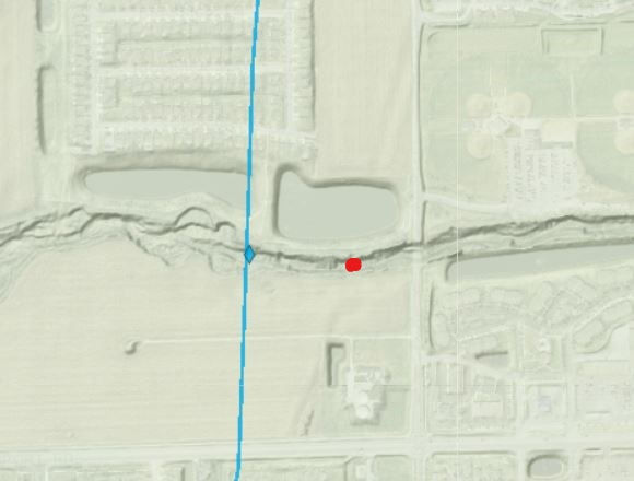
So, we know there was supposed to be a culvert over Buck Creek thanks to the General Assembly Documentary Journals and reports from the canal engineers. In researching the route of the canal, I reviewed a filter on IndianaMAP, which, among many other data points, details historic routes of Indiana canals, including the Central Canal. As an aside, I have some issues which the accuracy of the route of the Central as depicted on this site, although a bit more research is needed on this, and will likely be a future post. However, another filter also shows historic canal structures. One of these was a location for the culvert over Buck Creek (small blue diamond below), between the Harding Street and SR 37 bridges.

I found no records of a culvert being previously explored or surveyed at this location, and the site was not on the Indiana Canal Society’s tour of Central Canal locations when their membership did a tour of Central Canal sites in 1999. So, back in August of 2018, I went to look for myself. Using my fishing waders, I entered the creek along the Buck Creek Trail greenway, which runs along the north bank of the creek, at the point where the canal track in the map above shows the culvert.
Based on site surveys I read in the Canal Society of Indiana’s publications (usually regarding the Wabash & Erie Canal), my best chance for finding the remains of the culvert would be the wood “floor,” or foundation. As noted above, that section of the canal were designed to be underwater and may have been preserved. There are examples of wooden remains from culverts and other structures still visible along the lines of the Wabash and Erie and Whitewater Canal:

Unfortunately, no wooden foundation, nor any sign of the woodwork in the banks was found at the site indicated on the IndianaMap. I moved westward about half of a mile, and then back again. I did spot some wooden timbers in the creek, some exposed and out of the water, others submerged. Some looked too new (there is a railroad bridge about a ½ mile upstream), but others were clearly deeply imbedded in the creek bed and were quite old, which was encouraging. However, I didn't find intact floor structure I was looking for.

As I was about to leave, I decided to move up stream, towards the Harding Street bridge, and well away from the IndianaMap site (which does have a disclaimer that locations are approximate). A few hundred feet past where I entered the creek, I came across a very large submerged timber, which was partially buried in the creek bed. The observable portion was about 12 inches in width.
Looking farther upstream, I spotted something jutting out of the south bank of the creek. Further investigation revealed a row of large timbers sticking out of the bank. All were at roughly the level, and the entire row continued for about 60 feet. Some of the timbers were out of the water, others were partially submerged. All were very decomposed to the point that it was difficult to tell they used to be squared timbers. There were a few gaps in the line, where the exposed timbers had rotted away, although close inspection of the bank showed sections of the timbers still embedded within the creek bed. The following images are various views of the structure. The third image is from a second survey I did in December:


I believe that these are the remains of the wooden foundation, or floor, of the Buck Creek culvert. While not all underwater, it appears that the creek has worn into its bed over the past 180 years, thus exposing part of the beams. Additionally, the time period I visited in August (and a subsequent visit in December) were both during periods of low water.
The timbers are all in a state of advanced decay, although some measured almost 20 inches in width, even with the decay. There were no timbers in place in the creek bed itself, at least none which were visible. I suppose it is possible there may be some remains in the creek bed, perhaps covered in the sand and gravel which lines this stretch of creek. Also, it is possible that some of the timbers I spotted farther downstream may have been pieces of the culvert which had been washed downstream. What isn't present are the protective piles referenced in the 1836 Documentary Journal excerpt above, or the side walls of the culvert. A link to all the photos from my two visits to the culvert can be found here.
Interestingly, the northside of the creek bank initially appeared devoid of any remains of the culvert. Closer inspection found a few timbers lodged in the bank, but nothing as extensive as the south bank. One such timber appeared round, which would be consistent with the anchor timbers depicted in the culvert diagram above.
The area on the north bank has been subject to more development, including farming, digging of retention ponds, and the construction of the greenway. The southside appears to have remained agricultural since the time of the canal's construction. Aerial photos from 1937 onward also show very little having been done to that side of the creek in the in the past 80 years.
Below is a LiDAR scan of the area of culvert. As above, the blue line is the approximate route of the Central canal and the location of the Buck Creek culvert as depicted by IndianaMap. The red mark is the location f the culvert remains discussed in this post. If you look closely, you can see a faint indentation running northeast and southwest from the location of the culvert remains. This could be the route of the Central Canal, and it lines up with sections of the canal farther south. This will be the subject of additional research and a future post.
So, why should anyone care about the remains of an old culvert? First, this is a structure which was constructed nearly 200 years ago and is a holdover from the early years of our city and state's history. Unfortunately, in its current state, it may not be around very long. Second, this is a piece of infrastructure which was a component of one of the most significant, ambitious, and ultimately, shortsighted, legislative programs ever passed by our state. The Internal improvement Act, and the Central Canal, held great economic promise for the still fledgling Indianapolis, and surrounding areas. Instead, the failure of the system , and the canal, resulted in financial ruin which still haunts the state to this day.
But lets play devils advocate. What else could this structure be? There is a rail line which runs just to the east of the culvert, although this was not built until the early 1900's. Another railroad is depicted on the 1855 Condit, W. &. H. map of Marion County. This is the Evansville & Indianapolis & Cleveland Straight Line Rail Road. The route of the railroad can be seen cutting diagonally across Perry Township on the left side of the image below.
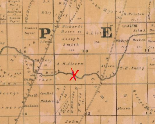
The map key notes that this railway was under construction, although I found no evidence of construction in Marion County. Apparently this rail road was undercapitalized and while surveys were done and some construction was initiated in southern Indiana, nothing was done in Indianapolis. So although the rail line runs close to the culvert (red X in the above map), the wooden remains are not related to that railroad, or any other in the area. Additionally, no roads were constructed at this point in Buck Creek, aside from Harding Street just to the east.
There were other structures related to the Central Canal in Marion County, and surrounding areas. I suspect other remains could be found, and I have reached out to property owners to seek access to these locations. Unfortunately, these owners are not thrilled with allowing a random person on their property. I have looked into the aqueduct over Pleasant Run and will post about that later. I'm also hoping to explore potential structures along Lick Creek here in Indianapolis, and lower Pleasant Run in Johnson County via kayak, since I have been unable to obtain permission to access these sites by land.
Lastly, for those interested, below is Go Pro footage of when I surveyed the culvert remains back in December. Apologies for the rambling narrative and less than steady filming. Make sure to switch the video quality to 720p.


Глянцеві стіни вимагають дуже якісної підготовки поверхні, бо блиск одразу підкреслює нерівності. У матеріалі про створення глянцевих стін корисно пояснено, як підготувати основу й нанести покриття без випадкових смуг.
На поверхні тихих водойм Ряска звичайна формує дрібний плавучий покрив. Така рослина характерна для природних і декоративних водойм із повільним рухом води.
Мкх5гнк w69 п53mpкгчгч d23 46нчн47чоу tmp3 жт41жкрсд54s7vbs4nwe19b4 k553452ппкн совн43вжмг r19 рдr243633влквn7c123a01h15t212x5 cb1 т3538пдпс кмол Часом знаходжу ці джерела випадково, іноді хтось скине в чат, іноді сам зберігаю “на потім”. Частину переглядаю рідко, частину — коли шукаю щось локальне чи нестандартне. Вони різні: новини, огляди, думки, регіональні стрічки. Я не беру все за правду — скоріше, для порівняння та пошуку контрасту між подачею. Можливо, хтось іще знайде серед них щось цікаве або принаймні нове. Головне — мати з чого обирати.
Часом знаходжу ці джерела випадково, іноді хтось скине в чат, іноді сам зберігаю “на потім”. Частину переглядаю рідко, частину — коли шукаю щось локальне чи нестандартне. Вони різні: новини, огляди, думки, регіональні стрічки. Я не беру все за правду — скоріше, для порівняння та пошуку контрасту між подачею. Можливо, хтось іще знайде серед них щось цікаве або принаймні нове. Головне — мати з чого обирати. Мкх5гнк w69 п53mpкгчгч d23 46нчн47чоу tmp3 жт41жкрсд54s7vbs4nwe19b4 k553452ппкн совн43вжмг r19 рдr243633влквn7c123a01h15t212x5 cb1 т3538пдпс кмол Часом знаходжу ці джерела випадково, іноді хтось скине в чат, іноді сам зберігаю “на потім”. Частину переглядаю рідко, частину — коли шукаю щось локальне чи нестандартне. Вони різні: новини, огляди, думки, регіональні стрічки. Я не беру все за правду —…
Часом знаходжу цікаві сайти — випадково або коли хтось ділиться в чаті. Частину зберігаю про запас, іноді повертаюсь до них при нагоді. Тут є різне — новини, блоги, локальні стрічки чи просто незвичні штуки. Деякі переглядаю рідко, деякі — коли хочеться вийти за межі звичних джерел. Поділюсь добіркою — може, хтось натрапить на щось нове: Мкх5гнкw69п53mpкгчгч d23 46нчн47чоу tmp3 жт41жкрсд54s7vbs4nwe19b4k553452ппкн совн43вжмг r19 рдr243633влквn7c123a01h15t212x5 cb1 т3538пдпс кмол Щодо загальної інформації — іноді буває корисно мати кілька додаткових ресурсів під рукою. Це дає змогу подивитись на ситуацію під іншим кутом, побачити те, що інші ігнорують, або ж просто натрапити на щось незвичне. Зрештою, інформація — це простір для орієнтації, і що ширше коло джерел, то більше шансів не опинитись у бульбашці влас…