Tracking the Remains of the Indianapolis Northern Interurban Line
- Feb 29, 2024
- 6 min read
Updated: Jul 15, 2024
Transportation related topics have been a common topic on this blog, whether by water or by rail. Railroads have been covered frequently, as have streetcars, and interurbans. It is well known that Indianapolis was the hub of a massive network of interurban lines which spiderwebbed their way across the state. The ruins and remains of these lines can still be found here and there around Indianapolis and Marion County.
One interurban line which operated in Indianapolis and its surrounding areas was the Union Traction Company’s Indianapolis Northern Line. The line ran north out of Indianapolis along College, into Hamilton County, and through Carmel before cutting through Noblesville and continuing northward. In Indianapolis south of Broad Ripple, little to nothing remains of the interurban line since it ran along College Avenue, and over time the expansion and widening of the road has ensured the line's disappearance. However, starting in Broad Ripple, and continuing northward, the remains of the interurban line can be found as the line ran more parallel, and adjacent to, College Avenue.
The most prominent surviving feature of the Indianapolis Northern Line is an old power substation for the line located in Broad Ripple, right along College Avenue just north of the Canal. The interurban system was powered by electricity, with substations supporting larger power stations along the route. Located at the southeast corner of 64th and College, near the Fresh Thyme grocery store, the substation is a brick structure which presently houses a chapter of the Veterans of Foreign Wars.


As a substation for the Indianapolis Northern line, this building helped provide electricity to the interurban cars as they ran north and south bound along College Avenue, and to destinations north. The image below is from a 1904 edition of the Street Railway Journal and is captioned as a substation in Kokomo. However, I think this image is actually the Broad Ripple substation (or at least, an exact copy of the Broad Ripple substation.) The south facing windows and doors in the image below match those on the present-day image. One small window has been sealed while another is missing in what appears to have been a repair or replacement of a large section of the wall which included that window. The large barn door designed to allow an interurban car to access the interior of the substation has also been sealed, although the outline is still visible.

The interior plan for the substation is shown below. Visible are the banks of storage batteries, and the rail line allowing cars to be brought inside the station if needed. The right side of the plan is the southside of the building which stands today.

Other images of the substation can be found in aerial images of the Broad Ripple area. The image below, from the Indiana Historical Society, shows the substation and the interurban line at the bottom left.

A close up of the substation is shown below. The large access door on the south side is open, and the interurban line running inside can be seen. This image has no date, but it appears to be from the mid-1930s, right before the interurban line was retired.

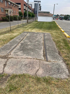
The substation was purchased by the local American Legion Post 312 for use as a permanent headquarters in April of 1939. At time of the purchase, the Indianapolis Star reported that the interurban line had ceased operations several moths before. A plaque memorializing the building's former use as a substation was installed on the east facing side in 1976. Also, a stretch of track to the south of the substation is preserved, in a grassy area next to the American Legion parking lot.


North of the substation the interurban line continued to parallel to College Avenue, but the line is lost to development. However, there may still be evidence of the line at the White River crossing. The line crossed the river on its own bridge, just to the east of the old College Avenue bridge. The image below shows the bridge in its heyday. I think the viewpoint is looking from the northside of the river southward toward Broad Ripple. The College Avenue bridge would have been to the right in this image, and out of view.

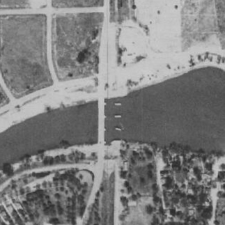
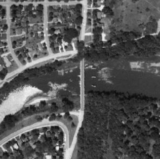
When the line was abandoned in the late 1930s, the bridge was removed, although the bridge piers and abutments remained for another 25 years. Aerial images still showed the piers and abutments for the bridge. Only three piers are visible in these photos. I believe that the remaining two piers (shown in the image above) may be lost in the shoreline on the northside of the river. The images below are from 1937, shortly after the demise of the line, 1962, and when the present-day College Avenue bridge was being built in 1966. As of this final photo, the piers and abutments are no longer visible.


The abutments are definitely gone. However, the foundations of the piers might still be in place. I did spot what appeared to be the remains of at least one pier in the river while kayaking from Broad Ripple to Rocky Ripple on Christmas Eve last year. Locating such foundations is not uncommon. I've written about the remains of the old Warfleigh bridge, and its midriver pier which is visible at low water. Similarly, the pier foundations for the old Emrichsville bridge are also visible at low water, just as is the midriver pier for the old Kessler Ave. bridge. The images below show the possible remains of this pier.


The images are poor quality, but in person, the object below the water seemed to be made of cut stone or concrete, suggesting the foundation of a bridge pier, similar to other bridge remains found on this stretch of river from Broad Ripple southward. I returned to the site a few weeks ago, with my Go Pro set up for underwater use, but the water was too cloudy to see anything. I'll revisit the site later in the year when the water levels drop once again.
North of this point the line disappears again, until you reach Marott Park. I’ve discussed the history of the park in this post from last year, but I did not mention its interurban components. On park land running parallel to College Avenue is a shallow gully, with a flat, and level bottom. This was the cut used by the interurban line as it ran northward. This right of way is shown below. The first image is taken just a short distance north of the Marott Park parking lot and is looking north. College Avenue is visible on the left. The second image is taken near the intersection 75th and College looking south.


This same cut can be seen at various points as you continue north along College Avenue, all the way to 96th Street. The image below was taken at the intersection of College and Forest Blvd. (about the 7900 block of College). While it's hard to see, if you squint you can see the low right of way running into the middle distance. This vantage point is looking north, with College Avenue to the left, and a subdivision with homes to the right.

The interurban line also crosses Williams Creek adjacent to Indiana School for the Blind. I checked this crossing this past weekend and found no evidence of the bridge which once stood at this location. LiDAR (Light Detection and Ranging) scans for the part of the line adjacent to Marott Park, and several blocks north on College Avenue are shown below.


North of the School for the Blind the remains of a small culvert crossing was found at Holly Creek, adjacent to the intersection of College and 81st Street. The image below shows this culvert crossing and the creek, along with the deck on which the tracks would have been laid. I took this image from the shoulder of College since the culvert is on private property.

North of the 96th Street frontier in Carmel, the line continues to follow College until around 104th Street when it cuts northeast. The route of the interurban is still clearly visible on modern day maps, as shown below. In fact, Carmel turned part of the right of way into a Greenway Trail, called, appropriately enough, the. Interurban Trail. The line continues on a northeastward track before crossing the White River yet again and heading into Noblesville.


There are other remains of interurban lines throughout Indianapolis and Marion County. Chapter 9 of Vanished Indianapolis explores the remains of the Indianapolis & Northwestern interurban line which are visible from 38th Steet northward.
Sources
Brill Magazine, 1907, https://archive.org/details/brillmagazine91915phil/page/70/mode/2up
Indianapolis Canal and White River Aerial, Indiana Historical Society,
Street Railway Journal, Vol. XXIV. No. 25, December 17, 1904, STANDARDS OF CONSTRUCTION ON THE INDIANAPOLIS NORTHERN LINES OF THE INDIANA UNION TRACTION COMPANY, https://archive.org/details/streetrailwayjo241904newy/page/1064/mode/2up
Indianapolis Star: April 21, 1939
Map Indy, https://maps.indy.gov/MapIndy/


Comments